The Main Range Walk in Kosciuszko National Park is one of the most scenic alpine hikes in Australia. This 22 km loop takes you past glacial lakes, alpine ridgelines, and Australia’s highest peak, Mount Kosciuszko, offering some of the best mountain scenery in the country.
In this guide, based on the hike we did in January 2023, I’ve put together everything you need to plan your own hike, including trail sections, highlights, conditions, and practical tips.
Main Range Walk: Overview
While most visitors head to the summit of Mount Kosciuszko via the shorter 12 km return track from Thredbo, the Main Range Walk offers a far more rewarding experience. It is a longer loop, but the extra effort pays off with more breathtaking views of the mountain ranges and glacial lakes.
Main Range Walk: Quick Overview
- Location: Kosciuszko National Park, NSW, Australia
- Distance: 22 – 23 km
- Time: ~7-9 hours
- Elevation gain: ~800 m
- Highest point: Mt Kosciuszko summit (2,228 m)
- Trailhead: Charlotte Pass
- Trail type: Loop
- Difficulty: Challenging – Grade 4
- Best time: December to March
- Highlights: Blue Lake, Lake Albina, Mount Kosciuszko summit, alpine views
- Park entry fees: during hiking season: $17 per vehicle per day, bus passengers $6.60 per adult
- Public toilets: Available at Charlotte Pass and Rawson Pass
Main Range Walk Trailhead
The trail begins at Charlotte Pass (1,835 m), a trailhead for several other hikes. Even early in the morning, parking can fill up quickly. If you do this hike on a long weekend or during Christmas break, I recommend arriving as early as possible. We arrived just before 7 am and managed to park very close to the trailhead, but by the time we returned, there was nearly a kilometre-long line of cars parked along the road. Coming later will easily add 1-2 km to your hike.

Main Range Walk Direction (Clockwise vs Anticlockwise)
Main Range Walk is a loop, so it can be completed in either direction. We hiked anticlockwise. This way, we covered the steepest sections earlier in the day, while we were still fresh, and finished with a mostly downhill stretch.
For those looking to extend the adventure, there’s also the option to turn this into a multi-day hike, with detours to Australia’s Eleven Highest Peaks.
Main Range Walk: Trail Notes
Charlotte Pass to Blue Lake
The first section of the Main Range Walk from Charlotte Pass to Blue Lake is around 5 km and takes roughly 2 hours, according to the National Park sign.
The trail begins as a paved path through iconic snow gums, known for their twisted, colourful trunks. It continues downhill to the Snowy River, overlooking a spectacular valley where Club Lake Creek flows into it.

After about 700 m, we reached the lowest point of the trail. Here, we crossed the Snowy River and Club Lake Creek. There is a path of stepping stones to help cross them. But note that the stones become very slippery when wet, and crossings may be impassable after rain.

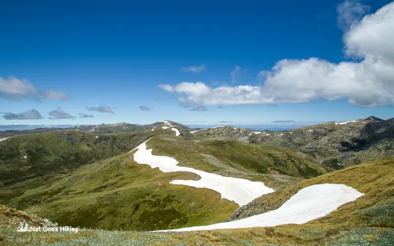
From there, we started to climb through open alpine terrain for around 3 km until we reached the turnoff to Blue Lake lookout. Blue Lake is an optional side trip, which is only a 1 km return and is well worth it. In my experience, it’s one of the highlights of the entire Main Range Walk, and many hikers actually walk only as far as Blue Lake before returning to Charlotte Pass.
Blue Lake

We did the hike at the end of January 2023, and at that time, access beyond the lookout was closed for environmental regeneration. The track to Blue Lake beyond the lookout, Blue Lake Creek, and Hedley Tarn was not accessible.
Blue Lake is a stunning glacial lake sitting at around 1,890 m above sea level and known for its striking blue color.
It is the largest of the four cirque lakes on mainland Australia. The other three are Club Lake, Lake Albina, and Lake Cootapatamba. All four of them are located in Kosciuszko National Park and can be seen along the Main Range Walk.
Blue Lake to Carruthers Peak
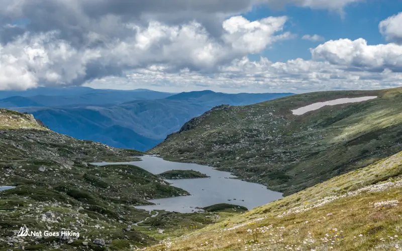
From Blue Lake lookout, we returned to the main trail and continued the uphill hike toward Carruthers Peak (2,145 m), the seventh highest peak in Australia. Soon, we reached a saddle with a breathtaking view of the ranges.

The trail continues climbing to Carruthers Peak, where we were rewarded with stunning views of the surrounding alpine landscape. In my opinion, this section of the hike has some of the best scenery on the Main Range Walk.
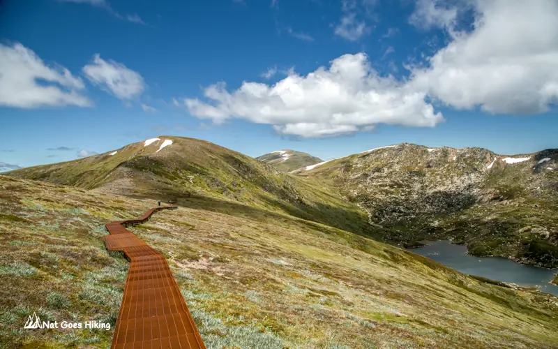
Carruthers Peak to Muellers Pass
From the summit, we started descending along the ridge. The stone path soon turned into a metal-grate walkway, making this section an easy, flat hike. Along the way, we were admiring beautiful Lake Albina from above. As we continued hiking further to Muellers Pass, the metal grate walkway gave way to a stony path, and the trail started ascending again. Soon we reached Muellers Pass. From here, if you think you have enough time and energy, you can take an optional side trip to Wilkinsons Creek.
Muellers Pass to Mount Kosciuszko summit
We continued from Mueller Pass toward Mount Kosciuszko, ascending a stone path that gradually gave way to a rubber mesh trail. Along the way, we were treated to stunning views of the Snowy River Valley on our left and fractured granite formations on our right. Eventually, we reached the intersection with the Summit Track
At the intersection, turn right to hike toward the summit of Mount Kosciuszko, just 990 meters away. From this point, the trail becomes noticeably busier. Over 100,000 people climb Mount Kosciuszko each year. There are a lot of people hiking to Mount Kosciuszko via Thredbo to Kosciuszko Walk or the Summit Walk from Charlotte Pass. Unlike other mountain summits in Kosciuszko National Park, the trail to the summit is very well-maintained.

As we approached the summit, we noticed scaffolding at the top of Mount Kosciuszko. It turned out that NSW National Parks was building a ramp to make the summit accessible to people with limited mobility.

At the summit, we paused for a snack and soaked in the panoramic views of the surrounding alpine landscape.
Mount Kosciuszko summit to Rawson Pass
From Mount Kosciuszko, it’s an easy, scenic descent toward Charlotte Pass along the Summit Walk. We retraced our steps to the intersection, then continued another 680 m to Rawson Pass. Rawson Pass is the junction where the Summit Walk from Charlotte Pass meets the metal walkway from Thredbo. There is a toilet here, which is the highest public toilet in Australia, along with a mountain bike parking stand.
Hike Section: Rawson Pass to Charlotte Pass

From Rawson Pass, the Main Range Walk follows a wide gravel fire trail leading to Charlotte Pass. This section of the trail is suitable for mountain bikes. The trail goes along the Etheridge Range, and after about 1.7 km we reached Seaman’s Hut, a cabin built in 1929 and now used as an emergency shelter.


The trail continues for about 1.4 km down to the Snowy River. There are bridges across the Snowy River and Merritts Creek. From the river, it’s about 4.5 km to Charlotte Pass. The track follows the Snowy River, with views of the valley on the left. The scenery doesn’t change much along this stretch, but the final kilometre passes through a grove of beautiful snow gums.
Main Range Walk: Practical Info
If you’re planning the Main Range Walk, this is the stuff you actually need to know before you go. It’s an incredible hike, but it’s also alpine terrain. Conditions can change fast, even in the middle of summer.
Weather and conditions
Don’t underestimate the weather, and always check the forecast the night before and again in the morning. The weather in Kosciuszko National Park is unpredictable.
Even in summer, weather conditions can change suddenly and very dramatically. One minute it’s clear skies, next minute you’re in cloud or wind. Even in summer, temperatures can drop quickly. Wind exposure is high on ridgelines. On one of our hikes in January, we got caught in a hailstorm.
UV exposure
UV is high across Australia, and it’s even stronger in the Australian Alps than at sea level because of the elevation. There’s very little shade along the trail, so even in cooler months, sunscreen, sunglasses, and a hat are essential.
Best Time for Main Range Walk
The Main Range Walk is open from November to May, and the best time to hike the Main Range Walk is in the summer months from December to March. During this time, the weather is warmer and more stable, with longer daylight hours. Wildflowers are blooming. That said, it’s also the busiest time.
Shoulder seasons are November and April. This time is quieter, but the weather is less predictable, and the temperatures are cooler, especially in the mornings and evenings.
What to pack for the Main Range Walk
For the Main Range Walk, you want to be prepared but not overloaded.
Essentials:
- Plenty of water
- Snacks or lunch
- Warm layers – in summer, a fleece jacket or a light puffer jacket is sufficient
- Rain jacket
- Hat
- Sunscreen
- Sunglasses