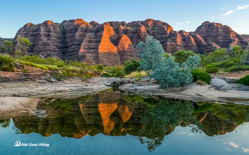
The Piccaninny Gorge Trek is the most remote and rewarding hike in Purnululu National Park, better known as the Bungle Bungles, in Western Australia’s Kimberley region.
The trail follows the wide creek bed of Piccaninny Gorge, surrounded by towering sandstone cliffs. Once you leave the day-hiking areas behind, the landscape feels wild and untouched. It’s the only hike in the Bungle Bungles where you can really escape the crowds.
If you love off-the-beaten-path adventures, the Piccaninny Gorge Trek is easily one of the most unforgettable in Western Australia. My partner and I did the trek in June 2023, and it’s honestly one of my favourite hikes in the country. In this guide, I’ll cover everything you need to know about the Piccaninny Gorge Trek, including trail notes, difficulty, safety tips, water sources, and more.
Overview of the Piccaninny Gorge Trek
Piccaninny Gorge Trek – Quick Facts
- Location: Purnululu National Park, Kimberley, Western Australia
- Type of trail: Return
- Trail difficulty: Exceeds standard trail classification (WA Parks and Wildlife Service classification)
- Distance: 25–40+ km, depending on how many side gorges you explore
- Duration: 2–4 days, depending on how many side gorges you explore
- Water source: Black Rock Pool is the only reliable water source, located about 9 km from the trailhead
- Best time to hike: June to August (dry season in the Kimberley)
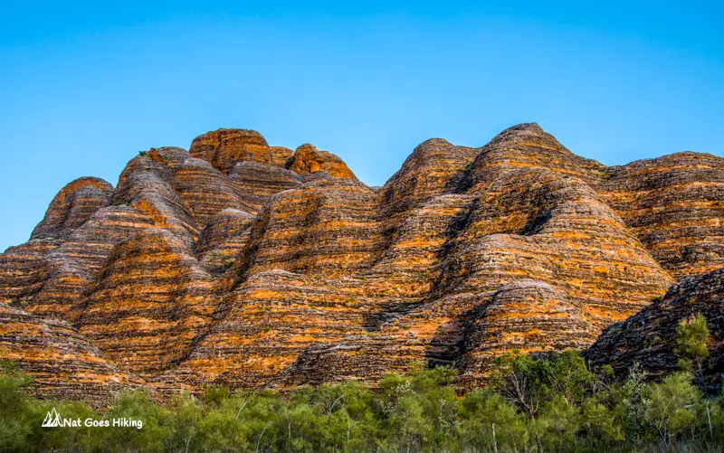
The Piccaninny Gorge Trek is one of the most remote and adventurous hikes in Western Australia. This multi-day hike is roughly 25-40+ km, depending on how many side gorges, or “fingers”, you decide to explore. There are 5 side gorges. The trail takes you into the heart of the Bungle Bungle Range, where Piccaninny Creek has cut a deep gorge through the main plateau, allowing you to explore the impressive gorge system. During the winter months, the creek is dry, and the Piccaninny Gorge hike follows the creek bed and its tributaries.
This is a return hike that usually takes 2 to 4 days, but it can take longer depending on how many of the five side gorges you explore. If you’re sticking to the main gorge, 2 days and 1 night is enough. But if you want to check out all the side gorges, you’ll need an extra one or two days.

Piccaninny Gorge Trek Difficulty
When we hiked the Piccaninny Gorge Trek in 2023, WA Parks and Wildlife Service rated it as a Class 5 trail. Since then, the classification has been updated, and as of 2026, it’s listed as “exceeds standard walk trail classification“. It means the hike is only suitable for very experienced hikers. You should be self-sufficient, in great shape, and confident with advanced navigation skills.
If you are not planning to explore all the side gorges, 2 days and 1 night are enough to complete the hike. However, you will require an extra one or two days to explore the gorges.
The Piccaninny Gorge Trek is unmarked
There are no signs or track markings, so you’ll need to rely on your own navigational skills. However, following Piccaninny Creek makes it more or less straightforward.

The tricky part is that once you’re in the gorge, the tall sandstone walls can block GPS signals. It means sending messages via a satellite communicator can be tricky. We actually met a couple struggling to get their Garmin InReach to send messages while inside the gorge. This is something to keep in mind if you’re planning to use a satellite communicator.
Terrain and Hiking Challenges
While the walk along Piccaninny Creek is mostly flat, loose cobbles, sand, and occasional boulder hopping and scrambling in the Kimberley’s scorching 35-40°C heat can make it exhausting.
Exploring the side gorges is more challenging than hiking along the main gorge because of the rough terrain. Some gorges may be partially filled with water, requiring cold-water swimming, while others involve boulder hopping and scrambling over huge boulders.
Natural Hazards
The Kimberley’s heat can be extreme, with daytime temperatures often exceeding 40°C and the radiant sun making it feel even hotter. To stay safe, carry plenty of water. Carry at least one litre per person per hour. We tried to avoid the hottest part of the day by starting our hike before sunrise. Remember that heat stress is a serious risk in this environment, so don’t underestimate it.
Rockfalls are possible in the gorge. In 2023, access to Finger 4 was closed after rockfalls made it unsafe to hike into this gorge.
Piccaninny Gorge can flash flood, with water rising fast. Make sure to check the weather forecast before hiking, and don’t attempt the trek if rain is expected. When we did the hike, the visitor centre advised us not to stay in the gorge for more than two days due to the rain forecast.

How to get to Purnululu National Park
Purnululu National Park sits deep in Western Australia’s Kimberley region, a remote and sparsely populated area in the northeastern part of the state. It’s remote, rugged, and absolutely stunning – think towering sandstone domes, stunning gorges, and total wilderness.
If you’re planning the Piccaninny Gorge Trek, getting here is part of the adventure. Most visitors drive in from either Kununurra in the north or Halls Creek in the south.
Getting from Kununurra
We drove from Kununurra, and it took roughly half a day. In Kununurra, it’s a good idea to fill up on fuel and stock up on water and groceries before hitting the road.

Spring Creek Track
From Kununurra, you’ll take the Great Northern Highway for about 250 km. Keep an eye out for the signposted turn-off to the park. From there, the adventure begins on the unsealed Spring Creek Track, which is 53 km of serious corrugation and a few creek crossings. You’ll need a high-clearance 4WD. Honestly, it was one of the roughest unsealed roads we’ve ever driven in Australia

Getting from Halls Creek
If you’re coming from the south, Halls Creek is the closest town, about a 100 km drive to the park’s turn-off. You can fill up the fuel, and there’s a caravan park, but from what I saw, it’s not the most pleasant place to stay overnight.
After finishing the hike, we drove towards Halls Creek but didn’t stop there. Instead, we kept going to Fitzroy Crossing. We arrived after dark, couldn’t find anywhere to stay, and ended up driving another 90 km to camp at Ellendale Station Rest Area.
Flying
Another option is to fly into Kununurra. From there, you can hire a 4WD, stock up on water and groceries, and drive the 250 km drive along the Great Northern Highway to the park turn-off.

Piccaninny Gorge Trek Trailhead
The Piccaninny Gorge Trek begins from the Piccaninny Creek carpark, around 27 km from the Visitor Centre. Before we set off, we stayed at Walardi Campground. This campground is the closest to the trailhead, about a 17 km drive. It made a perfect base to get an early start on the hike.

Important things to know before starting the Piccaninny Gorge Trek
Registration
For your safety, you must register at the visitor centre before starting the hike. The Visitor Centre opens at 8 am. We registered the day before, so we could start the hike as early as possible to avoid the heat, and it was a smart move.
Upon completing the hike, you have to sign off to prevent any search-and-rescue worries. We agreed to sign off the day after we finished because the Visitor Centre closes at 4 pm. Just a heads-up: both registering and deregistering are compulsory, so plan ahead.
Personal Locator Beacon
Carrying a personal locator beacon (PLB) is compulsory on the Piccaninny Gorge Trek. If you don’t have your own, you can hire one at the Visitor Centre for $20, with a $200 deposit.

Pay for camping
Additionally, you need to pay for camping at the Piccaninny Gorge. You can do it online. As of 2026, camping costs $20 per person per night. Since there are no facilities, hikers must be self-sufficient and carry all camping gear, food, and water supplies.
The park entry fee is $17 per vehicle per day, or you can grab a Park Pass if you’re planning a longer stay.

Best time for Piccaninny Gorge Trek and seasonal closure
The best time for Piccaninny Gorge Trek is May to August, which is the dry season in the Kimberley. Purnululu National Park shuts down during the wet season from November to April, and the Piccaninny Gorge Trek is only open between May and September. Plan your trip within this window.
Weather
Daytime temperatures in the Kimberley can soar above 40°C, so be prepared for serious heat. Always check the weather forecast before heading out, and don’t attempt the hike if rain is expected—the creek bed can flash flood very quickly.
When we visited, the Visitor Centre advised us not to stay in the gorge for more than two days because of the forecast. So we kept our hike to two days. When we signed off at the centre, we learned the park might close due to the rain, and sure enough, it was closed the next day.
Water sources in the Piccaninny Gorge
The Black Rock Pool, about 1 km from the Elbow, is the only reliable water source in the Piccaninny Gorge. When we hiked in June, it had plenty of clean water, but since it’s used as a drinking source, swimming is strictly prohibited. Always treat water before drinking. There are some seasonal pools along the gorge, but the water there looked pretty filthy.

It’s recommended to carry around 1 litre of water per person per hour of hiking. We each carried 4.75 litres and refilled a 1.5-litre water bottle on both day one and day two on the way back. That was enough for about 1.5 days. We started very early on day one to avoid the heat, aiming to reach the shaded parts of the gorge before it got too hot, and returned to the car park by midday on day two.
Piccaninny Gorge Trek – Trail Notes
From the car park to the Elbow (8 km)
The Piccaninny Gorge Hike begins from the Piccaninny Creek carpark, initially following the same route as the other Southern walks. It’s an 8 km hike to the Elbow, mostly along a firm creek bed with the occasional loose cobble or sandy patch. Along the way, you’ll be surrounded by the iconic beehive-shaped Bungle Bungles, though there’s no shade until you reach the mouth of the gorge at the Elbow.

We registered at the Visitor Centre the day before so we could start early and beat the heat. That early start made a huge difference; we reached the Elbow in about three hours, just before the sun got intense.

From Elbow to Black Rock Pool (600m)
The Piccaninny Gorge starts at the Elbow. Once you’re inside the gorge, you’re mostly in the shade, which makes the hike a lot easier compared to the open creek bed.
From the Elbow, continue about 600 metres to the turn-off for Black Rock Pool. There’s no signage there, and it’s easy to miss it. From the turn-off, it’s a short boulder scramble down to the pool.

Black Rock Pool is the only reliable water source in the gorge. Many hikers choose to camp nearby so they’re close to water and can explore the side gorges more easily. Note that camping isn’t allowed on the sandy section right next to the pool.
We refilled our 1.5-litre water bottle there and then pushed further into the gorge.

From Black Rock Pool into the gorge
From Black Rock Pool, the gorge really starts to impress. Steep walls rise up to 200 m overhead, giving plenty of shade, which is a welcome relief from the sun. Walking on sand and loose cobbles can be tiring, though, so pace yourself.
We hiked about 5 km to the start of side gorge 5. At first, we thought about camping there, but decided to head back and set up camp halfway between side gorge 1 and side gorge 5. There are plenty of good spots along the way. Basically, you can camp anywhere between the Elbow and the end of the Piccaninny Gorge.

Exploring Piccaninny Gorge Side Gorges (Fingers)
Off the main gorge, there are five side gorges, arranged like the fingers and thumb of a right hand, so they’re often called the “Fingers and a Thumb.” The first gorge, or Thumb, sits on the left and is about 3 km from the Elbow.

Once you’ve picked a camp spot, you can start exploring the side gorges if you’ve got enough time and energy, or save it for the next morning. Hiking through the fingers is slower and more challenging than the main gorge. Some gorges may have water to swim through, while others require steep climbs, boulder hopping, and scrambling over rocks.

We only had time for one or two gorges. At the start of the hike, we met a couple who had hiked several and said Finger 5 was their favourite. So, we decided to check it out ourselves, and it didn’t disappoint.
Piccaninny Gorge Finger 1
Finger 1 involves swimming through a narrow, dark gorge. Some reports say it can take up to 40 minutes to get through, so it’s definitely for confident swimmers.
Piccaninny Gorge Finger 2
After the hike, I watched some videos online, and Finger 2 really stands out. The gorge has a remarkable cave and stunning rock formations that make it worth a visit if you have time.
Piccaninny Gorge Finger 4
As of June 2023, access to Finger 4 is closed. Due to rock falls, it is not safe to hike into this gorge.
Piccaninny Gorge Finger 5

Finger 5 was the only side gorge we hiked all the way to the end. It involves some boulder hopping and scrambling, and finishes in a cave with tunnels running under and between huge boulders. It’s challenging, but absolutely worth it.

Picanniny Gorge Trek FAQ
You don’t need a special permit, but you must register at the Purnululu Visitor Centre before starting the hike and sign off when you return. Carrying a Personal Locator Beacon (PLB) is also compulsory.
The only reliable water source is Black Rock Pool, located about 1 km from the Elbow. Water should always be treated before drinking. Seasonal pools sometimes appear in the gorge, but they may be dirty and unreliable.
The best time is May to August, during the dry season. In fact, Piccaninny Gorge Trek is only open between May and September.
The Piccaninny Gorge Trek is rated as exceeding standard walk trail classification, meaning it’s only suitable for very experienced hikers. There is no marked trail, so advanced navigation skills are required. You’ll walk on sand and loose cobbles, with occasional boulder hopping and scrambling, especially in side gorges. Some of the side gorges may also require swimming.
The Piccaninny Gorge Trek usually takes 2–4 days. The return hike is roughly 25–40+ km, depending on how many of the five side gorges (known as the “Fingers”) you explore.
If you stick to the main gorge, 2 days and 1 night are enough. However, exploring some or all of the side gorges typically requires 3–4 days.
Looking for the best day hikes on New Zealand’s South Island? Explore stunning alpine views, glacier lakes and must-do scenic trails for all levels.