About Mount Kaputar National Park
Mount Kaputar National Park is located about 570 km north of Sydney (7-8 hour drive) and encompasses a large portion of the Nandewar Ranges, the traditional country of the Gamilaroi people. The altitudes range from about 300 m to 1,509 m above sea level.
Undoubtedly, Mount Kaputar National Park is one of the must-visit national parks in NSW. It boasts dramatic landscapes and rock formations of the Nandewar Ranges created by volcanic activity millions of years ago. If you like hiking, you absolutely can’t miss this national park.
The park has three sections. All three of them are accessed from Narrabri:
Southern section (Kaputar Plateau): It is 58 km from Narrabri. From Narrabri take Old Gunnedah Rd and after about 2.5 km continue on Kaputar Rd. Most of the hikes are in this section of the park. Also, there are two campgrounds (Dawsons Spring and Bark Hut) and cabins available in this section.
Northern section (Sawn Rocks): 37 km from Narrabri. The northern and southern sections are not connected by road, so, unfortunately, to get to the Sawn Rocks you need to drive back to Narrabri, take the Newell Highway, and after about 5 km turn into Killarney Gap Rd and continue for 33 km. The main attraction here is the Sawn Rocks. There are no campgrounds in this part of the park.
Waa Gorge area (north of Sawn Rocks and is more isolated). 62 km from Narrabri. If you are coming from the Sawn Rocks take Killarney Gap Rd back for 12.5 km until turn off to Mellburra Rd, after 30 km turn to Allambie Rd and drive for another 7 km. The attraction here is Mill-Bullah Waterholes and Waa Gorge walking track.
My Top 4 Hikes in Mount Kaputar National Park
- Yulludunida walking track
- Sawn Rocks Walking Track
- Mount Kaputar Summit Walk
- The Governor lookout track
My personal favorites in Mount Kaputar National Park are Yulludunida walking track and Sawn Rocks lookout. Surely, only these two attractions make it worth the visit.
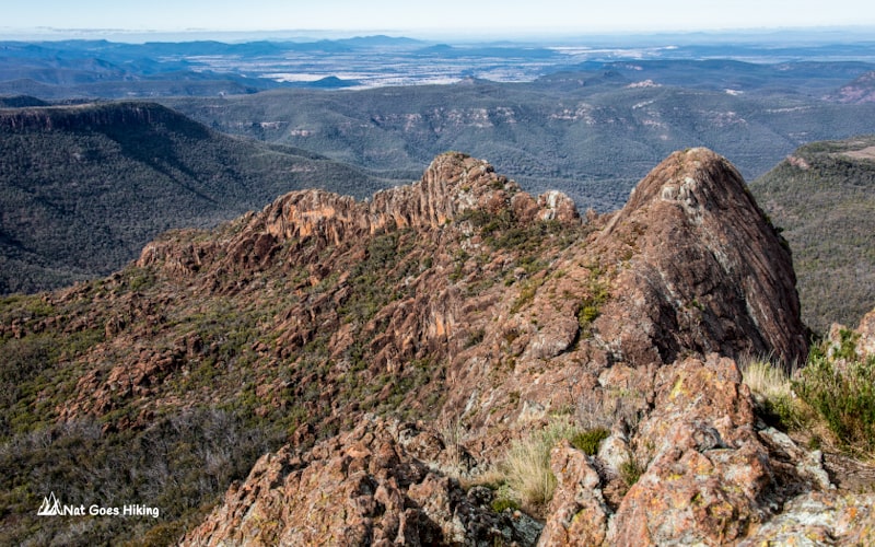
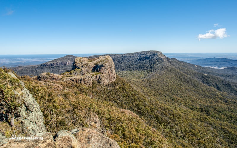
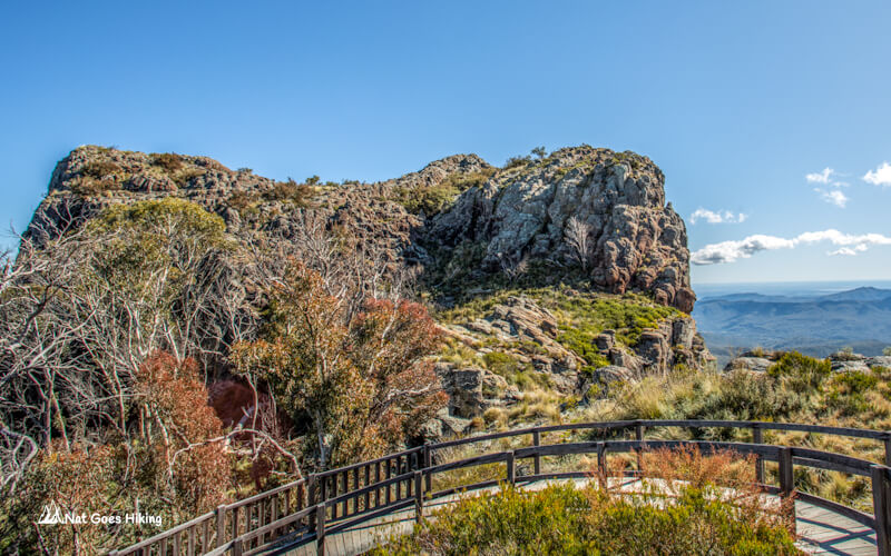
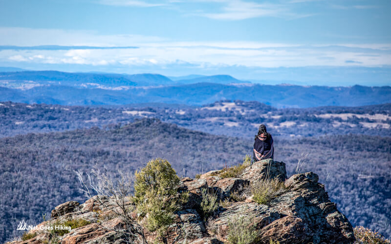
1. Yulludunida walking track
Yulludunida walking track is a challenging 4 km, 3 hours return hike to the top of Mount Yulludunida.
- Location: Southern section of Mount Kaputar National Park
- Trailhead: Green camp car park off Kaputar Road
- Distance: 4 km return
- Time: 3 hours return
- Elevation gain: 771 m from the car park to the summit (as per GPS navigator)
- Highest point: 1,225 m
Although the trail is quite short, it is the hardest of the short hikes in Mount Kaputar National Park. It may be short, but it is steep with an elevation gain of about 770 km. Once you get to the top, the views are absolutely stunning. Without a doubt, so far it is my favorite hike in NSW.
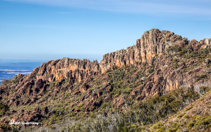
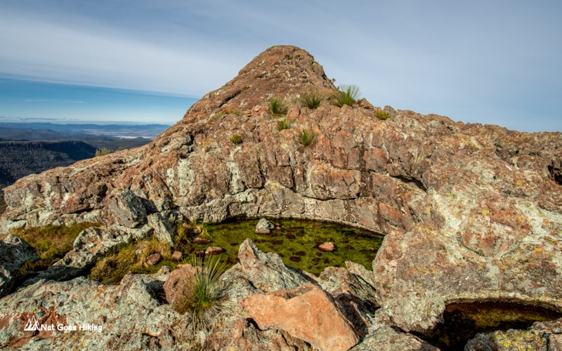
From Green Camp car park it’s a 350 m climb up the stairs through the bush. There will be pretty views on the way, but this is just the beginning. Once you come out of the bush, you will find yourself on a rock face and will be rewarded with a spectacular view of the Yulludunida crater, which is actually not a crater, but a ring dyke.
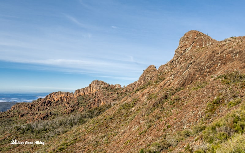
The marked section of the trail ends here, but you can scramble over rocks to the top of Mount Yulludunida. This section of the trail is unmarked, so you need to find your way up the side of a steep bluff. I am glad we climbed to the top, and it was not as difficult as it looked. But be careful and make sure you wear sturdy shoes. Indeed, the 360 degrees view from the top is really worth all the effort.
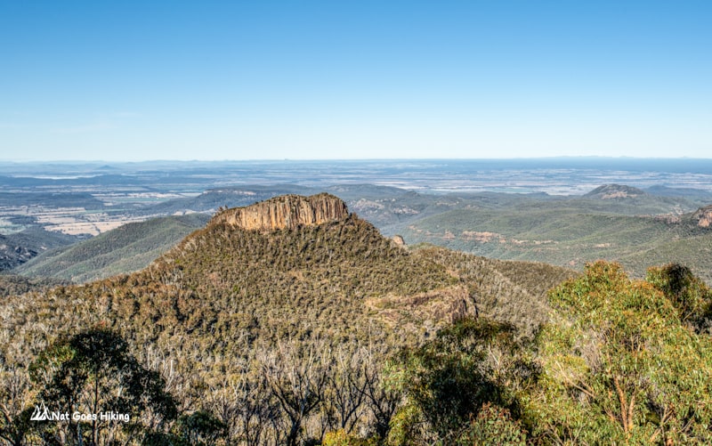
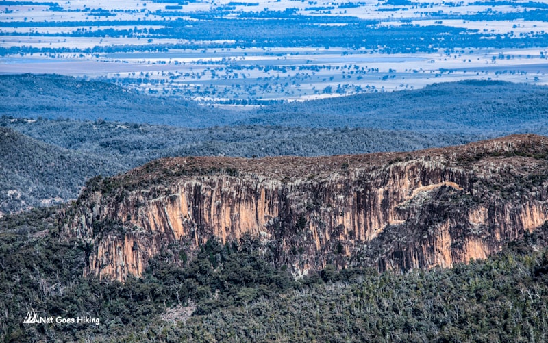
2. Sawn Rocks Walking Track
- Location: Northern section of Mount Kaputar National Park
- Trailhead: Sawn Rocks car park off Killarney Gap Rd
- Distance: 1.5 km return
- Time: 20-30 min return
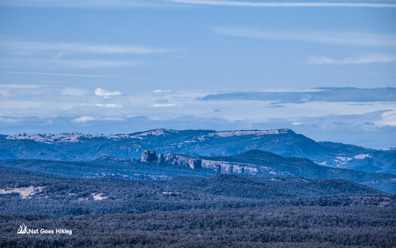
This is a very short and very easy walk through semi-arid bushland to the Sawn Rocks, an amazing rock formation that looks like a wall of giant organ pipes. This rock formation is the result of the slow cooling of molten rock. The basalt cools from the outside toward the centre, and this causes shrinkage cracks to form, commonly, in a hexagonal pattern.
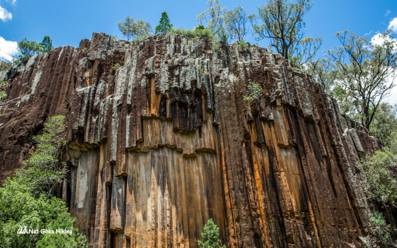
Tip for taking photos: get here after midday when the sun shines on the Sawn Rocks face.
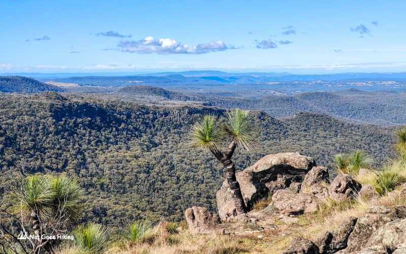
3. Mount Kaputar Summit Walk
- Location: Southern section of Mount Kaputar National Park
- Trailhead: Dawsons Spring picnic area
- Distance: 2 km return
- Time: 45 min – 1 hour 15 min return
- Elevation gain: 121 m
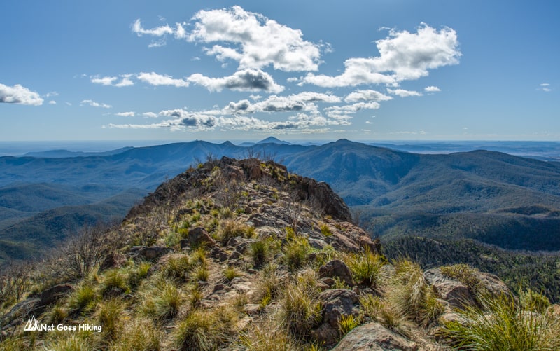
Mount Kaputar (1,509 m) is the highest point in the park, so you get uninterrupted 360 degrees views from the top.
Please do yourself a favor, don’t be lazy like me, and come either for sunrise or sunset. You can also just drive to the lookout. We went during the day, so the sunlight was too harsh for taking photos.
The trail itself is not very exciting, so if you drive to the lookout, you do not lose much.
4. The Governor lookout track (Corrunbral Borawah)
- Location: Southern section of Mount Kaputar National Park
- Trailhead: The Governor car park off Kaputar Road
- Distance: 2 km return
- Time: 45 min – 1 hour return
- Elevation gain: 84 m
The track has two parts: the first 300 m is an easy flat wheelchair accessible walk to the Governor lookout, and the second part takes you to the top of a large volcanic plug (The Governor) and involves a bit of rock scrambling.
Other hikes in Mount Kaputar National Park
- The Kaputar Plateau Walk
- Bundabulla Circuit walking track
- Scutts Hut – Kurrawonga Falls Walk
- Euglah Rock Track
- Dawsons Spring Nature Trail
- Lindsay Rock Tops Walk
- Mount Coryah Walk
- Mill-Bullah Waterholes and Waa Gorge walking tracks
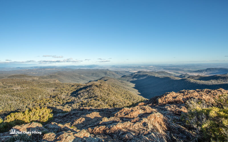
5. The Kaputar Plateau Walk
- Location: Southern section of Mount Kaputar National Park
- Trailhead: can start at Bark Hut or at the start of Rocky Plateau Fire Trail
- Distance: 8 km loop
- Time: 2.5 – 3.5 hours
This is a moderate walk along fire trails (Rocky Plateau fire trail and Scutts trail). The downside is it includes about 2 km walk along the main road (Kaputar Rd).
There are beautiful lookouts along this walk: Doug Sky Lookout, Laird Lookout, Rangers Lookout, but on the whole, it was a bit boring and not as exciting as Yulludunida walking track.
6. Bundabulla Circuit walking track
- Location: Southern section of Mount Kaputar National Park
- Trailhead: Lindsay Rock Tops carpark. You can also start at Dawson Springs campground and come back via Dawsons Spring Nature Trail.
- Distance: 3 km loop
- Time: 2 – 3 hours
It is a medium 3 km loop around Kaputar Plateau with several nice lookouts on the trail: Bundabulla lookout, Eckford lookout, Horsearms lookout.
If you start at Dawson Springs campground and come back via Dawsons Spring Nature Trail, it adds up extra kilometres to the track. The trail can get a bit muddy and slippery.
7. Scutts Hut – Kurrawonga Falls Walk
- Location: Southern section of Mount Kaputar National Park
- Trailhead: Bark Hut campground
- Distance: 19 km return
- Time: 10-12 hours
- Elevation gain: 805 m
It is the longest walk in the park and can be done as an overnight walk. The trail follows the Scutts Hut fire trail for about 7 km and then turns left and goes steeply down to Scutts Hut and Kurrawonga Falls.
8. Euglah Rock Track
Euglah Rock Track is an easy 2 km return walk to Euglah Rock lookout. The view of Euglah Rock is very similar to the view from Doug Sky lookout, but at a slightly different angle.
- Location: Southern section of Mount Kaputar National Park
- Trailhead: Bark Hut campground
- Distance: 0.65 km return
- Time: 15-30 min
9. Dawsons Spring Nature Trail
It is a pleasant easy walk with a small seasonal waterfall falling into Horsearm Creek. Currently the trail is partially closed due to a fallen tree over the bridge.
- Location: Southern section of Mount Kaputar National Park
- Trailhead: Bark Hut campground
- Distance: 1.4 km loop
- Time: 30 min – 1 hours
10. Lindsay Rock Tops Walk
Lindsay Rock Tops Walk is an easy track that can be combined with Bundabulla Circuit. It leads to an open lava field with panoramic views of the plains to the south and east.
- Location: Southern section of Mount Kaputar National Park
- Trailhead: Lindsay Rock Tops car park. You can also start at Dawson Springs campground
- Distance: 2 km return
- Time: 30-45 min
11. Mount Coryah Walk
It is a moderately challenging walk up the lava terraces to the summit of Mount Coryah. You will be rewarded with scenic views of the surrounding mountainous landscape.
- Location: Southern section of Mount Kaputar National Park
- Trailhead: Coryah Gap car park off Kaputar Road
- Distance: 4 km return
- Time: 1 – 2 hours
- Elevation gain: 259 m
12. Mill-Bullah Waterholes and Waa Gorge walking tracks
These are the only two walks in Waa Gorge area of Mount Kaputar National Park.
Mill-bullah walking track brings you to Mill-bullah waterholes. From there you can continue on Waa Gorge tracks leading to Waa Gorge.
- Location: Waa Gorge area of Mount Kaputar National Park
- Trailhead: Waa Gorge car park off Allambie Road
- Distance: 2.5 km return
- Elevation gain: 93 m
Pingback: 6 Must-Visit National Parks in NSW (Australia) - Nat Goes Hiking