Grand High Tops Walk also known as Breadknife and Grand High Tops Walk (14.5 km) is considered one of the best walks in NSW. If you have time for only one hike in Warrumbungle National Park, it should be this one. It offers stunning views of the Warrumbungles volcanic landscape with impressive rock formations. The spectacular 360-degree view from Lugh’s Throne is a highlight of this hike.
We decided to hike Breadknife and Grand High Tops extended overnight walk (approx distance is 35 km) over 2 days. If you prefer to do one-day hikes, I have a post on the Best hikes in Warrumbungle National Park.
Grand High Tops Overnight Walk – Day 1
Our extended route included 5 separate trails:
- Breadknife and Grand High Tops Walk
- Goulds Circuit track
- Bluff Mountain track
- Mount Exmouth and Cathedral and Arch track
- Burbie fire trail
The trail begins from Pincham car park if you go in a clockwise direction. Alternatively, you can start from Split Rock car park and hike in a counter-clockwise direction.
Goulds Circuit track
From the car park, we followed Breadknife and Grand High Tops walk. After 1.8 km we took a turnoff to a Goulds Circuit. This is a side loop that adds a couple of kms to the trail.
Apparently, Goulds Circuit trail is not so popular, as the path is narrow and not as well maintained as Grand High Tops Walk. But Febor Tor and Macha Tor lookouts are really worth hiking to.
They offer great views of iconic rock formations: Belougery Spire, Crater Bluff, the Breadknife, Bluff Mountain, and others from a different less known angle.


After returning back to Grand High Tops Walk you soon reach a turnoff to Spirey View Lookout which is only 150 m walk from the main path. It offers another view of Belougery Spire and the Breadknife.

From Spirey View Lookout it is about 2.6 km to Lugh’s Throne. So far, the trail has been more or less flat, but soon the incline gets steeper, and you have to climb a steep set of stairs. Belougery Spire will be on your left.
Once you reach the end of the stairs there will be a turnoff to Balor Hut. In case you run out of water, you can refill your water bottle there, it is about 100 m walk along Dagda track.
From the end of the stairs, it is another 700 m to Lugh’s Throne. The track goes uphill climbing alongside the Breadknife. By the time you get to Lugh’s Throne, in total, the trail gains more than 300 m of elevation.
Lugh’s Throne
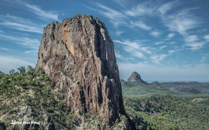
Lugh’s Throne offers 360 degrees views of dramatic volcanic scenery and striking rock formations: the Breadknife, Belougery Spire, Crater Bluff, Bluff Mountain, Tonduron Spire, and others. The view is mind-blowing, it is one of the best views in NSW and is really worth climbing all those stairs.

The Breadknife is the most recognizable landmark and one of the most striking volcanic formations in Australia. It is dyke formed by volcanic activity. It is about 90 meters tall but is only 4 meters thick in many places.

From Lugh’s Throne, we headed to Dow’s camp along the Grand High Tops Walk, it was about a 2 km hike.
Bluff Mountain (1203 m)
Ascent to Bluff Mountain starts from Dow’s camp, it is about 1.3 km and 230 m elevation gain. We left our packs at the camp and took only water and a camera. Bluff Mountain is the second highest point in Warrumbungle National Park after Mount Exmouth and gives you 360 degrees view from a higher point and a different angle.

After returning to Dow’s camp we headed towards Ogma camp where we stayed for the night. If you do Grand High Tops Walk only, from Ogma camp you usually return to Pincham car park via West Spirey track.

After Dow’s camp, the trail was very quiet, we met one family between Dow’s camp and Ogma camp and one couple at Ogma camp who were heading back to the car park. We haven’t met anyone on Day 2 until we reached Split Rock car park.
Grand High Tops Overnight Walk – Day 2

Cathedral and Arch
The next morning after a quick breakfast we headed to Cathedral and Arch. To get there take a sidetrack from the main trail, which is about 0.5 km one way. There is a clear sign, so you won’t miss the turnoff. Don’t skip it, as the views are really worth the hike.


Cathedral is upright rock formations looking like a cathedral. It is easy to find, but the Arch seems harder to locate. I read a couple of reviews where people could not find the Arch. Once you get closer to it, there is no obvious path and no signs. We just continued walking using GPS to locate it.
The Arch is an amazing natural rock bridge connecting two outcrops. But that’s not all, a lonely gum tree grows right in the middle of the bridge.

Mount Exmouth (1206 m)
After returning to the main track we walked to the turnoff to Mount Exmouth. We packed all our staff in one backpack and left it near Danu camp and took another one with a water bladder. According to the sign, it is 2.6 km to the top of Mount Exmouth, it took us about an hour to get to the top, and the elevation gain was more than 350 m.

I am really glad we did not skip it. We thought we could skip it, as we climbed Mount Bluff on Day 1. But Mount Exmouth is the highest peak in Warrumbungles, and it was still only 8.30 am, so we decided to hike to Mount Exmouth. The view was absolutely rewarding.
Burbie Fire Trail
Once you return to the main trail, it is a 5.8 km walk to Split Rock car park via Burbie Fire Trail. We were running low on water, so after about 2.2 km, we stopped at Burbie camp which had a water tap. We refilled our water and had lunch there.
Burbie Fire Trail is quite a boring walk with no special views except for Belougery Split Rock view closer to the end of the trail.
The trail ends at Split Rock car park which means you have to walk another 3.5 km along the road to get back to Pincham car park.
Things to keep in mind
- Best time to visit: Spring, when wildflowers are in bloom and temperatures are moderate.
- Water: take enough water especially if you go in summer. There is water at Balor Hut and Burbie camp.
Costs
- Park entry fees $8×2 days =$16
- Ogma camp booking fee $6
- Camp food (Backcountry meals) $14.39 x 3 = $43.17
- Beef jerky: $10
- Cereal bars: $3.5
- Fuel from Sydney: 146 litres / $244
- Total: $322.67
Nice views there 🙂