New Zealand’s South Island is home to some of the most spectacular hiking in the world. During our two-week road trip across the island, we explored some of the best day hikes on New Zealand’s South Island: from easy walking tracks to rewarding alpine viewpoints.
Hiking is not only the best way to see New Zealand’s breathtaking landscapes, but it also helps you stay on a budget. If you’re planning a trip and want unforgettable landscapes without committing to multi-day treks, these South Island day hikes offer dramatic mountains, glacier-fed lakes and well-marked trails that are mostly free to access.
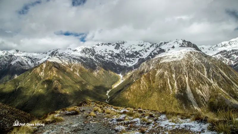
Mueller Hut Route
Location: Aoraki / Mount Cook National Park
Time: 6–8 hours return
Distance: 10 km / 6.2 miles return
Elevation gain: 1,050 m / 3,445 ft
Highest altitude: 1,800 m / 5,906 ft
Trailhead: White Horse Hill campsite
Difficulty (DOC grading system): Advanced: Tramping track
The Mueller Hut Route is one of my top South Island day hikes: dramatic alpine views and unforgettable scenery make it a must-do. Indeed, the views there are absolutely dramatic. When I visited, it was cloudy, and the clouds hid Mount Cook. Nevertheless, the scenery was absolutely spectacular.
The hike starts at White Horse Hill campsite and is easy and flat until you reach the foot of the Mueller Range. The trail is about 5 km long, but it’s pretty steep, with an elevation gain of roughly 1,050 m.
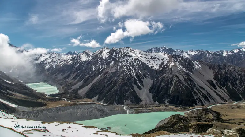
The first section of the trail follows the Sealy Tarns Track. There are about 2,200 steps over an elevation of about 600m to reach Sealy Tarns. From there, the path to Mueller Hut becomes more challenging: the trail is rugged, and the ascent steepens, with an additional 450 m of elevation to reach the hut.
While the hike can be completed in a single day, you can also stay overnight at Mueller Hut. You can experience an unforgettable alpine sunset, a magical sunrise, and starry skies. Make sure to book your hut spot well in advance, or pitch a tent nearby. The adult hut fee is $55.
When I reached the top, the wind was incredibly strong, making it hard to stay for long. I didn’t stay overnight since I didn’t have a booking, and it was still early in the day. After enjoying the views, I hiked back down and had lunch at White Horse Hill campsite before continuing on the Hooker Valley Track.
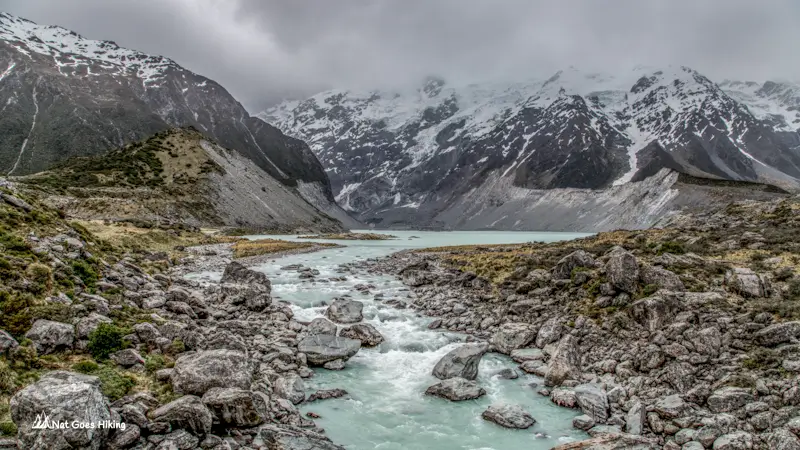
Hooker Valley Track
Location: Aoraki / Mount Cook National Park
Time: 3 hours return
Distance: 9 km / 5.6 miles return
Elevation gain: 100 m / 330 ft
Trailhead: White Horse Hill campsite
Difficulty (DOC grading system): Easy: Walking track
Surface: Gravel & boardwalks
Hooker Valley Track starts at White Horse Hill campsite, goes past Mueller Lake and then along the Hooker River and brings you to milky blue Hooker Lake.
It is an easy and flat track with mind-blowing views, but it’s also a heavily trafficked one.
Hooker Valley Track has by far the highest reward-to-effort ratio. It is ideal if you don’t have a lot of time to explore Mount Cook NP and want to go for an easy hike with spectacular views.
You will cross three different suspension bridges, and the entire way, you have non-stop mountain views with magnificent Aoraki /Mount Cook as your backdrop.
When I did the hike, it was cloudy, so Aoraki was hidden in the clouds, which is very common. Aoraki, the Maori name of the mountain, means ‘cloud piercer’, as the top of the mountain is very often hidden in clouds. Nevertheless, the views are jaw-dropping even on a cloudy day. ⠀
The trail is very well-maintained and easy to follow, with a mixture of gravel paths and boardwalks. With only 100m of elevation change, this hike is doable for a beginner hiker.
Key Summit Track
Location: Fiordland National Park
Distance: 6.8 km / 4.2 miles return
Time: 3 hours return
Elevation gain: 400 m / 1,300 ft
Trailhead: The Divide carpark on the Te Anau – Milford Sound road, about 83 km from Te Anau
Difficulty (DOC grading system): Intermediate: Great Walk / Easier tramping track
Key Summit Track is the start of the amazing Routeburn Track and offers magnificent views of Fiordland National Park.
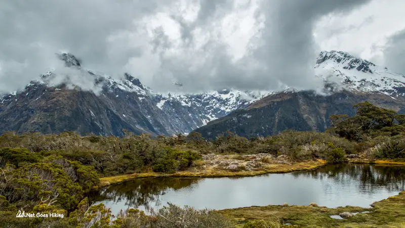
The first part of the hike runs uphill through native New Zealand bush. After about an hour, there will be a turnoff to Key Summit. From there, it’s about 20 minutes to the top, and the views get more beautiful the higher you climb. From Key Summit, you will see panoramic views over the Humboldt and Darran Mountains, and there’s a short loop track taking you around the summit.
Bealey Spur Track
Location: Arthur’s Pass National Park
Time: 4–5 hours return
Distance: 13.4 km / 8.3 miles return
Elevation gain: 836 m / 2,743 ft
Trailhead: Car park off West Coast Rd, 15 km east of the Visitor Centre; go up Cloudelsey Rd to get to trailhead
Difficulty (DOC grading system): Easy: Walking track
Bealey Spur Track starts as a gentle hike through mountain beech forest. Higher up, it passes through tussock grasslands, subalpine scrub, and several tarns.⠀
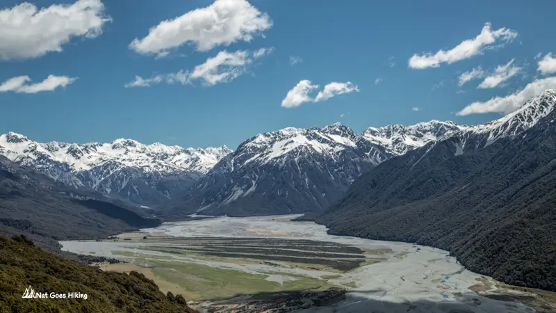
The trail brings you to Bealey Spur hut, but you also have an option to go further up to 1545 Hill for a 360° view of mountains, valleys and braided rivers. The track to 1545 Hill is unmarked. Please allow an extra 1.5 hours.
Bealey Spur Track can get quite muddy in some parts, so don’t forget good sturdy boots.
Temple Basin Track
Location: Arthur’s Pass National Park
Time: 3 hours return
Distance: 5.3 km / 3.3 miles return
Elevation gain: 490 m / 1,607 ft
Trailhead: SH 73 roadside car-park, 5 km north of Arthur’s Pass township
Difficulty (DOC grading system): Easy: Walking track
Temple Basin Track is one of the most scenic trails in the area. It starts from SH 73 roadside car park, 5 km north of Arthur’s Pass township.
The trail starts as a 4WD gravel track and then zigzags up the hill to the Lockwood Shelter. When you get there, you will be rewarded with mind-blowing views of Mt Rolleston across the valley. ⠀
It was cloudy on the day I hiked, and Mt Rolleston peak across the valley is hidden in the clouds⠀
Rob Roy Glacier Track
Location: Mount Aspiring National Park
Distance: 10.3 km / 6.2 miles return
Time: 3–4 hours return
Elevation gain: 522 m / 1,712 ft
Trailhead: Raspberry Creek carpark, 54 km west of Wanaka on the Wanaka–Mt Aspiring Road
Difficulty (DOC grading system): Easy: Walking track
I decided to do the Rob Roy Glacier Track instead of Roys Peak Track, which is a very popular track near Wanaka with a spectacular view from the top. I thought Roys Peak Track would be more crowded, so we went for Rob Roy Glacier, and met only 2 people on the way there.

After about 1.5km from the car park, there is a swing bridge over the Matukituki River. After crossing the bridge, you mostly hike through the beech forest, which was a bit boring. But once you get to the lookouts, the view of the Rob Roy glacier is spectacular.
The last 30km of the road from Wanaka to the start of the trail are unsealed, and the last 10km have several small water crossings that can get impassable in rainy weather. Check road conditions before going. ⠀